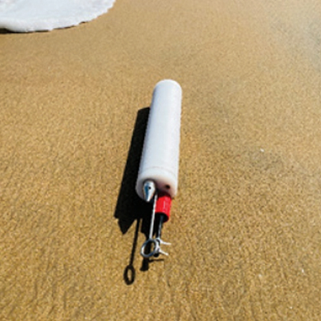
1. Body of the Profiler made out of high-density plastic.
2. Pressure port: The sensor which measures the hydrostatic pressure.
3. Key hole: Two different length of KEYs are provided to be used at different times of its operation.
4. Underwater connectors: Two nos. for different applications.
5. Two hooks provided at the two ends of the Profiler.
6. Towing hook: Used to tow the Profiler from Point Y to Point X.
7. Reverse pulling hook: Used to pull back the profiler in reverse direction, in case the Profiler gets stuck inside the water.
Near Shore Profiling System:
Hydrostatic pressure sensor to measure the depth of the water column with specialized electronics to remove the fast fluctuations caused by waves or other water movements caused by boats etc.
Principle of measurement : Hydrostatic pressure based.
Range of measurement : 0 to 10 meters.
Accuracy : 0.5% of FS.
How it works:
The Shore Profiler is equipped with two hooks at both ends of its body. Tie an 8mm plastic rope to the hook close to the *underwater connector and carry the profiler to the farthest point on a boat or dingy (The place where the mapping of the ocean floor has to begin). Use the *KEY to start the recording of the Profiler. Drop the profiler from the boat towards the ocean floor. Now one end of the rope is tied to the profiler, which is lying on the ocean floor and the other end at the beach. The profiler continuously starts to record the data every 2 seconds. The data is recorded as time verses depth. You may begin to slowly pulling the profiler using the rope from the beach side. The pulling of the rope in a uniform speed, as far as possible to make sure that the time axis is not disturbed. Once the Profiler reaches the shore side/comes out of the water, you may stop the process. The entire data can be downloaded to a computer directly in Microsoft Excel/CSV file format. The data is presented as depth verses time which is the profile of the ocean floor.
*KEY – Provided with two keys.
1. KEY-1: To switch OFF the Profiler after use. Helps to switch off the battery after use, to avoid over
drain of the internal batteries.
2. KEY-2: To start the recording of the Profiler.
River Bed Profiler
The sensor which has hooks on both ends of the profiler, can be ties to a rope and then taken towards both sides of the river bank. Start to drag the profiler from Point X to Point Y or vice versa, which is the cross section of the river. The Profiler records the changes in the profile of the river bed by taking the water level as the reference. Once the Profiler reaches the other side of the bank, the user can down load the data to a computer. The data will be available Microsoft Excel/CSV format with date and time. Any changes in water level due to disturbances caused by boat movement, waves etc. is measured and subtracted to get the actual bed profiler data.
